
Fichier:Congo-Brazzaville regions map.png
Taille de cet aperçu : 502 × 600 pixels. Autres résolutions : 201 × 240 pixels | 402 × 480 pixels | 643 × 768 pixels | 857 × 1 024 pixels | 2 518 × 3 008 pixels.
Fichier d’origine (2 518 × 3 008 pixels, taille du fichier : 1,67 Mio, type MIME : image/png)
Description
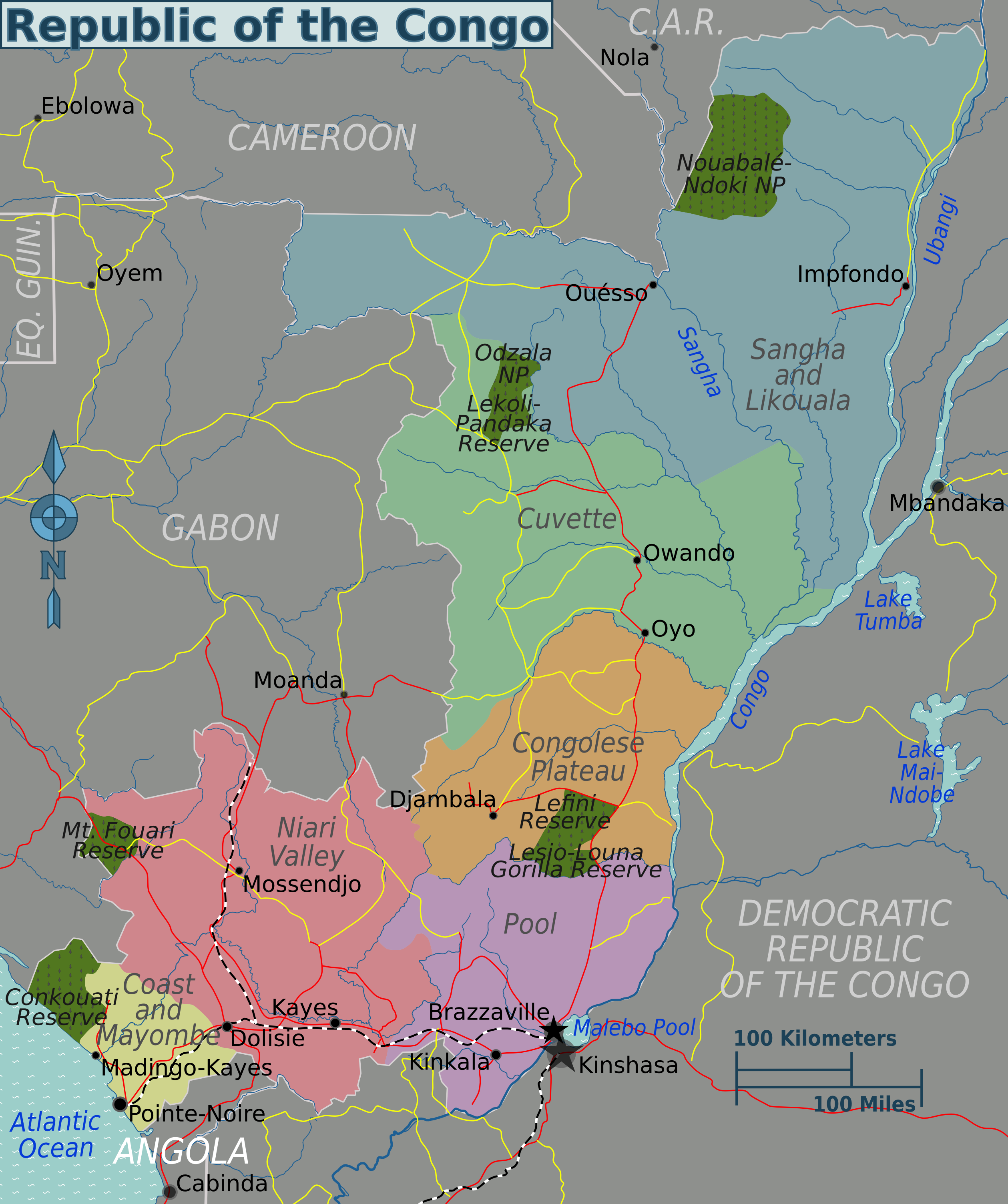
| Description | Republic of the Congo regions map for use on Wikivoyage, English version | ||||
| Date | |||||
| Source |
Travail personnel based on the UN map
|
||||
| Auteur | Peter Fitzgerald | ||||
| Autres versions | SVG source |
Conditions d’utilisation
Ce fichier est disponible selon les termes de la licence Creative Commons Attribution 3.0 Non transposée.
- Vous êtes libre :
- de partager – de copier, distribuer et transmettre cette œuvre
- d’adapter – de modifier cette œuvre
- Sous les conditions suivantes :
- paternité – Vous devez donner les informations appropriées concernant l'auteur, fournir un lien vers la licence et indiquer si des modifications ont été faites. Vous pouvez faire cela par tout moyen raisonnable, mais en aucune façon suggérant que l’auteur vous soutient ou approuve l’utilisation que vous en faites.
Journal des téléversements d’origine
| Ce fichier a été téléversé à partir de Wikivoyage WTS. |
La page de description originale était ici. Tous les noms d'utilisateur qui suivent se rapportent à wts.wikivoyage-old.
- 2010-01-27 01:48 (WT-shared) Peterfitzgerald copie d'archive at the Wayback Machine 2518×3008 (1383251 bytes) == Summary == {{Imagecredit|credit=Peter Fitzgerald|captureDate=26 January 2010|location=Republic of the Congo|source=[[:Image:Congo-Brazzav (Import from wikitravel.org/shared)
- 2010-01-27 05:40 (WT-shared) Peterfitzgerald copie d'archive at the Wayback Machine 2518×3008 (1380311 bytes) (Import from wikitravel.org/shared)
- 2010-01-27 18:17 (WT-shared) Peterfitzgerald copie d'archive at the Wayback Machine 2518×3008 (1749637 bytes) (Import from wikitravel.org/shared)
Historique du fichier
Cliquer sur une date et heure pour voir le fichier tel qu'il était à ce moment-là.
| Date et heure | Vignette | Dimensions | Utilisateur | Commentaire | |
|---|---|---|---|---|---|
| actuel | 22 novembre 2012 à 06:42 | | 2 518 × 3 008 (1,67 Mio) | OgreBot | (BOT): Reverting to most recent version before archival |
| 22 novembre 2012 à 06:42 |  | 2 518 × 3 008 (1,32 Mio) | OgreBot | (BOT): Uploading old version of file from wts.wikivoyage; originally uploaded on 2010-01-27 05:40:37 by (WT-shared) Peterfitzgerald | |
| 22 novembre 2012 à 06:42 |  | 2 518 × 3 008 (1,32 Mio) | OgreBot | (BOT): Uploading old version of file from wts.wikivoyage; originally uploaded on 2010-01-27 01:48:40 by (WT-shared) Peterfitzgerald | |
| 17 novembre 2012 à 23:17 |  | 2 518 × 3 008 (1,67 Mio) | MGA73bot2 | {{BotMoveToCommons|wts.oldwikivoyage|year={{subst:CURRENTYEAR}}|month={{subst:CURRENTMONTHNAME}}|day={{subst:CURRENTDAY}}}} == {{int:filedesc}} == {{Information |description=Republic of the Congo regions map. English version, Republic of the Congo * Ma... |
Utilisation du fichier
La page suivante utilise ce fichier :
Usage global du fichier
Les autres wikis suivants utilisent ce fichier :
- Utilisation sur en.wikivoyage.org
- Utilisation sur he.wikivoyage.org
- Utilisation sur incubator.wikimedia.org
- Utilisation sur it.wikivoyage.org
- Utilisation sur ja.wikivoyage.org
- Utilisation sur pt.wikipedia.org
- Utilisation sur pt.wikivoyage.org
- Utilisation sur vi.wikivoyage.org
- Utilisation sur zh.wikivoyage.org