
Fichier:Inujima 01.jpg

Taille de cet aperçu : 708 × 600 pixels. Autres résolutions : 283 × 240 pixels | 567 × 480 pixels | 907 × 768 pixels | 1 209 × 1 024 pixels | 1 755 × 1 487 pixels.
Fichier d’origine (1 755 × 1 487 pixels, taille du fichier : 514 kio, type MIME : image/jpeg)
Description
| Description |
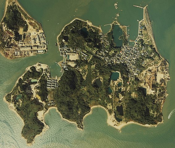
English: Inujima island in Okayama, Japan
日本語: 岡山県岡山市沖にある犬島全体の空中写真
|
| Date | |
| Source | 国土画像情報 (カラー空中写真) |
| Auteur | User:ラハール |
| Autorisation (Réutilisation de ce fichier) |
©Ministry of Land |
| Lieu de la prise de vue | | Voir cet endroit et d’autres images sur : OpenStreetMap |
|---|
Conditions d’utilisation

|
Le détenteur des droits d’auteur de ce fichier, Ministère du Territoire, des Infrastructures, des Transports et du Tourisme, autorise n’importe qui à l’utiliser pour n’importe quelle utilisation, pourvu que le détenteur des droits d’auteur soit correctement attribué. La redistribution, les œuvres dérivées, l’utilisation commerciale et toutes les autres utilisations sont autorisées. |
Attribution:
Copyright © National Land Image Information (Color Aerial Photographs), Ministry of Land, Infrastructure, Transport and Tourism
|
 |
This image is copyrighted by the Ministry of Land, Infrastructure, Transport and Tourism of Japan. For terms of use, see the stipulation to use of National Land Information (in Japanese) and message from MLIT (in Japanese and English). When you display this image on an article, include the following phrase in the description: "Made based on National Land Image Information (Color Aerial Photographs), Ministry of Land, Infrastructure, Transport and Tourism".
|
Historique du fichier
Cliquer sur une date et heure pour voir le fichier tel qu'il était à ce moment-là.
| Date et heure | Vignette | Dimensions | Utilisateur | Commentaire | |
|---|---|---|---|---|---|
| actuel | 8 novembre 2010 à 11:18 | | 1 755 × 1 487 (514 kio) | ラハール | 新年代、高精細度の画像に置き換え。 |
| 19 novembre 2007 à 18:50 |  | 495 × 512 (57 kio) | Okapia2~commonswiki | {{Information |Description=Inujima island in Okayama, Japan |Source=[http://w3land.mlit.go.jp/WebGIS/ MLIT Web Mapping System] (in Japanese) |Date=1980 (Edited 2007.11.16) |Author=Okapia2 (Editor) |Permission=This image is copyrighted by the Ministry of L |
Utilisation du fichier
La page suivante utilise ce fichier :
Usage global du fichier
Les autres wikis suivants utilisent ce fichier :
- Utilisation sur ceb.wikipedia.org
- Utilisation sur en.wikipedia.org
- Utilisation sur en.wikivoyage.org
- Utilisation sur www.wikidata.org