
Fichier:1989 Newcastle earthquake map.png

Taille de cet aperçu : 704 × 599 pixels. Autres résolutions : 282 × 240 pixels | 564 × 480 pixels | 902 × 768 pixels | 1 203 × 1 024 pixels | 1 500 × 1 277 pixels.
Fichier d’origine (1 500 × 1 277 pixels, taille du fichier : 1,07 Mio, type MIME : image/png)
Description
| Description |
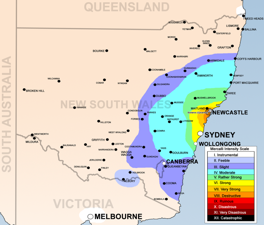
English: 1989 Newcastle earthquake map base on [1], [2], [3], [4] using the Mercalli intensity scale |
| Date | |
| Source | Data based on Geoscience Australia [5] and Own work by uploader |
| Auteur | Bidgee |
Conditions d’utilisation
Moi, en tant que détenteur des droits d’auteur sur cette œuvre, je la publie sous la licence suivante :
Ce fichier est disponible selon les termes de la licence Creative Commons Attribution 3.0 Non transposée.
- Vous êtes libre :
- de partager – de copier, distribuer et transmettre cette œuvre
- d’adapter – de modifier cette œuvre
- Sous les conditions suivantes :
- paternité – Vous devez donner les informations appropriées concernant l'auteur, fournir un lien vers la licence et indiquer si des modifications ont été faites. Vous pouvez faire cela par tout moyen raisonnable, mais en aucune façon suggérant que l’auteur vous soutient ou approuve l’utilisation que vous en faites.
Historique du fichier
Cliquer sur une date et heure pour voir le fichier tel qu'il était à ce moment-là.
| Date et heure | Vignette | Dimensions | Utilisateur | Commentaire | |
|---|---|---|---|---|---|
| actuel | 1 juin 2008 à 08:49 | | 1 500 × 1 277 (1,07 Mio) | Bidgee | {{Information |Description={{en|1=1989 Newcastle earthquake map base on [http://www.ema.gov.au/agd/EMA/emaSchools.nsf/Page/Lesson_Plans_Student_Worksheet_Student_Worksheet_-_Earthquakes], [http://www.ncc.nsw.gov.au/discover_newcastle/local_history/newcast |
Utilisation du fichier
Aucune page n’utilise ce fichier.
Usage global du fichier
Les autres wikis suivants utilisent ce fichier :
- Utilisation sur en.wikipedia.org
- Utilisation sur en.wikivoyage.org
- Utilisation sur es.wikipedia.org
- Utilisation sur fr.wikipedia.org
- Utilisation sur it.wikivoyage.org
- Utilisation sur ja.wikipedia.org
- Utilisation sur ko.wikipedia.org
- Utilisation sur www.wikidata.org
- Utilisation sur zh.wikivoyage.org