
Fichier:Bog Asphodel - geograph.org.uk - 1402752.jpg
Bog_Asphodel_-_geograph.org.uk_-_1402752.jpg (640 × 480 pixels, taille du fichier : 118 kio, type MIME : image/jpeg)
Description
| Description |
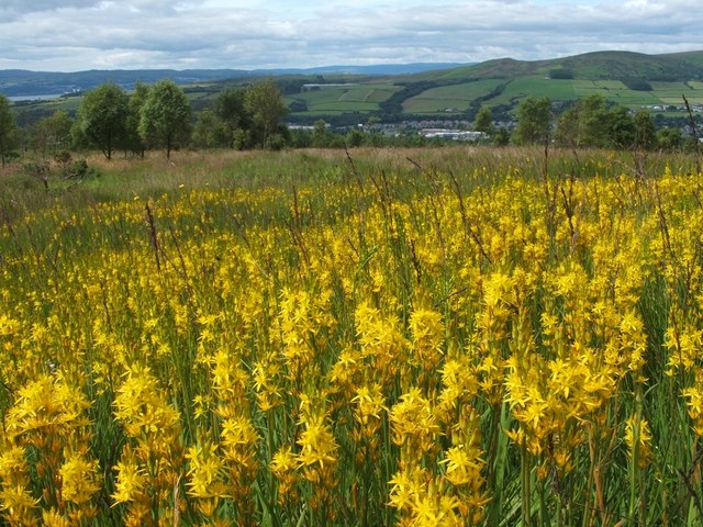
English: Bog Asphodel This is a closer view of some of the flowers that make up an extensive patch of Bog Asphodel (Narthecium ossifragum) on the grassy moors below Pappert Hill: 1402750.
This is a native species, found in bogs and other wet acidic habitats. After flowering, the dried-up remnants of the plant retain a strong orange-yellow colouring for quite some time. The specific name 'ossifragum' means 'bone-breaker'; as is explained in Richard Mabey's "Flora Britannica", that name is indirectly related to the habitat in which the plant is found: "it derives from the belief that grazing the plant made the bones of sheep brittle – though it was not bog asphodel which caused this, but the sour calcium-poor pastures in which it occurs". As for the background, a small part of the River Clyde can be seen at the far left. Slightly to the left of centre, visible as little more than a thin pale-blue line near the top of a hill, is Carman Reservoir. The hills to the right of centre are Carman Hill and Overton Muir. |
| Date | |
| Source | From geograph.org.uk |
| Auteur | Lairich Rig |
| Attribution (imposé par la licence) | Lairich Rig / Bog Asphodel / |
| Lieu de la prise de vue | | Voir cet endroit et d’autres images sur : OpenStreetMap |
|---|
_heading:247.00&language=fr)
| Position de l'objet | | Voir cet endroit et d’autres images sur : OpenStreetMap |
|---|
_heading:247.00&language=fr)
Conditions d’utilisation

|
Cette image provient de la collection du projet Geograph British Isles. Pour obtenir les coordonnées du photographe, veuillez consulter cette page de description de l'image sur le site du projet. Les droits d'auteurs sur cette image sont détenus par Lairich Rig ; l'image est placée sous une licence Creative Commons avec mention de paternité et partage à l'identique (CC-By-SA) en version 2.0.
|
- Vous êtes libre :
- de partager – de copier, distribuer et transmettre cette œuvre
- d’adapter – de modifier cette œuvre
- Sous les conditions suivantes :
- paternité – Vous devez donner les informations appropriées concernant l'auteur, fournir un lien vers la licence et indiquer si des modifications ont été faites. Vous pouvez faire cela par tout moyen raisonnable, mais en aucune façon suggérant que l’auteur vous soutient ou approuve l’utilisation que vous en faites.
- partage à l’identique – Si vous modifiez, transformez, ou vous basez sur cette œuvre, vous devez distribuer votre contribution sous la même licence ou une licence compatible avec celle de l’original.
Historique du fichier
Cliquer sur une date et heure pour voir le fichier tel qu'il était à ce moment-là.
| Date et heure | Vignette | Dimensions | Utilisateur | Commentaire | |
|---|---|---|---|---|---|
| actuel | 1 mars 2011 à 11:49 | | 640 × 480 (118 kio) | GeographBot | == {{int:filedesc}} == {{Information |description={{en|1=Bog Asphodel This is a closer view of some of the flowers that make up an extensive patch of Bog Asphodel (Narthecium ossifragum) on the grassy moors below Pappert Hill: 1402750. This is a na |
Utilisation du fichier
La page suivante utilise ce fichier :
Usage global du fichier
Les autres wikis suivants utilisent ce fichier :
- Utilisation sur be.wikipedia.org
- Utilisation sur cs.wikipedia.org
- Utilisation sur en.wikipedia.org
- Utilisation sur id.wikipedia.org
- Utilisation sur it.wikipedia.org
- Utilisation sur nn.wikipedia.org
- Utilisation sur uk.wikipedia.org
- Utilisation sur vi.wikipedia.org